Sproetau (Germany)
Methodology
The Sprötau investigation area is located in Thuringia (Germany). A total of 133 samples with a sampling interval of 1,000 and 500 m respectively was taken.
Results
Figure 1 shows a selected section with MPOG® oil- results. No significant signs of hydrocarbons were recorded in the entire investigation area. Out of 133 sample stations, 97.7% were located in normal background level, and 2.3% achieved slightly higher values. The well "Soeu Z1" was drilled in 1996 with a negative result. Moreover, there were no significant indications of gas accumulations in the entire investigation area.
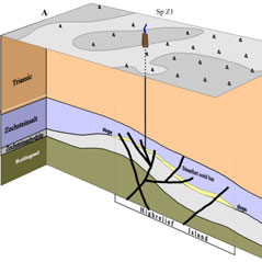
The geological situation and MPOG® -results along the profile A-A' are shown in figure 2.
Summary
The Ca2 of the Zechstein subdivision at the seismically identified Sprötau structure has almost the same geological structure and distribution of source rocks and reservoir rocks as the “Kietz” oil field.
The suprasalt is an almost unfaulted trap of the paleomorphological type. In contrast to the “Kietz” field, the maximum burial depth was only reached in Late Cretaceous. At this time, hydrocarbons were in the oil window. Influenced by Late Cretaceous inversion, basal Zechstein and suprasalt were overpressed and lifted by about 1,500 m. The paleolithic trap was intensely fractured. As a result, a possible oil accumulation was destroyed.
The source rock of the island slope is recently at a depth of about 1,000 m and thus at a temperature outside the oil window. The cooled off source rock recently stopped producing oil. In summary, the potential paleolithic oil field has been destroyed.


